

A new digital survey of megalithic tombs in Spain has revealed dozens of small burial mounds and a fortified hilltop settlement that once controlled a key Copper Age landscape in southern Iberia.
The research, led by Carolina Cabrero González and published in “Archaeological Prospection,” focuses on the necropolises of Fonelas in Granada province, Andalusia. The area belongs to the broader “Southeast Iberia Megalithic Phenomenon,” known for its dense clusters of small tombs built during the fourth and third millennia BC.
Early studies left major gaps in the record
Archaeologists first documented the region’s tombs in the 19th century. Explorers such as Louis Siret and Georg and Vera Leisner produced early drawings and maps, but their work lacked precise coordinates. Many tombs they described were later lost or impossible to relocate. Even a major excavation campaign in the 1970s and 1980s—led by researchers from the University of Granada—covered only a fraction of the wider landscape.
Remote sensing narrows dozens of possible sites
To solve this longstanding problem, Cabrero González and her team combined LiDAR-based digital models, aerial photography, and fieldwork. They began by scanning the terrain for circular mounds between 6 and 20 meters (20 and 65 feet) wide, a typical size for local dolmens.
The first digital pass identified 59 possible anomalies. Many proved to be traces of modern farming or livestock features. After cross-checking decades of aerial photographs, the team reduced the number to 40 likely prehistoric structures.
Fieldwork confirms half of the digital anomalies
Researchers walked the rugged terrain between December 2024 and March 2025. Using mobile mapping software connected to QGIS, they visited each anomaly and looked for upright stones, artificial mounds, looting pits, and scattered pottery or stone tools.

Of the 40 candidates, 20 proved to be positive archaeological sites. Thirteen are low, circular mounds with no visible internal chamber. Three are stone-built chambers. Three more are irregular structures likely linked to megalithic activity. One appears to be the negative footprint of a plundered tomb.
The 13 mound-like structures will undergo geophysical testing by late 2025 to confirm whether they are burial tumuli.
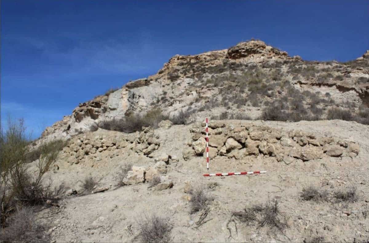
Fortified Copper Age settlement emerges at Cerro Leal
Beyond tombs, the researchers identified concentric linear anomalies on a hill known as Cerro Leal. Field inspection confirmed low dry-stone walls, some reinforced with semicircular buttress-like features.
Pottery, hand mills, mining tools, and copper minerals on the surface point to a fortified Copper Age settlement that may have continued into the Bronze Age. The natural cliffs on three sides and controlled eastern access suggest a strategic defensive layout.
A rediscovered burial ground shows signs of heavy looting
Around Cerro Leal, the team relocated seven megalithic tombs forming the Álamos Negros necropolis. Earlier records mentioned the site, but modern archaeologists had been able to identify only one tomb.
Today, the necropolis is in poor condition. Looters have left visible pits, metal probing rods, and ash-rich spoil heaps containing bone fragments and pottery. The tombs, mostly rectangular chambers measuring 1 to 2 meters (3 to 6.5 feet) long, reflect the small scale typical of the region’s megalithic tradition.
Drone photogrammetry produces highly accurate maps
To tie the evidence together, researchers used drone-based photogrammetry across 49 locations, including known graves and new candidates. Low-altitude flights produced detailed digital elevation models and orthomosaics.
By stripping away vegetation and modern clutter, the team mapped subtle mound outlines and wall traces with sub-centimeter precision.
Findings reshape view of Copper Age power in Iberia
The results strengthen the view that megalithic tombs and fortified hilltop settlements worked together to structure territory in Southeast Iberia. According to the study, communities placed tombs and defensive sites to control fertile land, river routes, and access to resources.
Cabrero González argues that Fonelas likely formed part of the broader political sphere centered at Los Millares, one of the major Copper Age hubs of the region. The combination of dense necropolises and defensive architecture suggests a highly organized society that managed land, labor, and symbolism through both the living and the dead.

